ARCHIRECTURE. HUMAN HABITATION
| ARCHTECTURE. HUMAN HABITATION |
Dr. Rafał Koliński/IA UAM
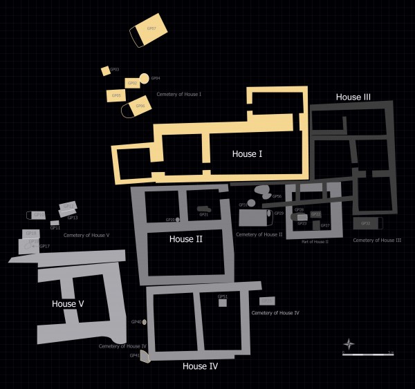
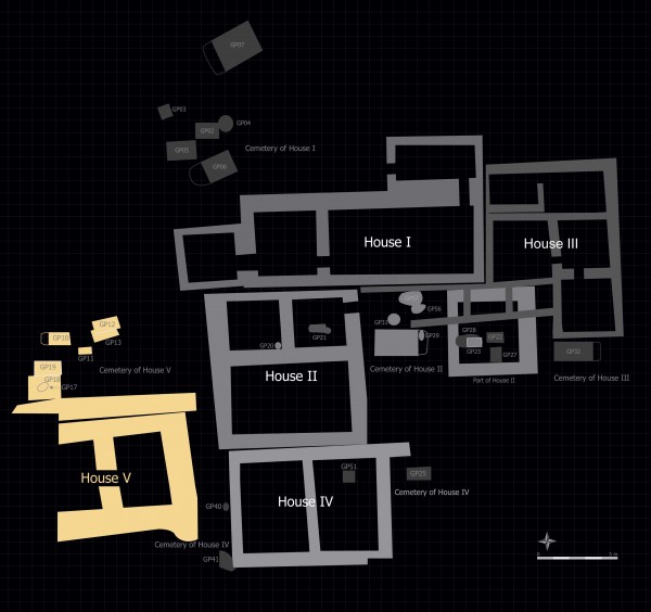
DISTRIBUTION OF HOUSES
Middle Bronze Age houses discovered in Sector SR/P of Tell Arbid stood on three terraces cutting into the eastern slope of the high mound. On the lowermost terrace, four houses (Houses I, II, III and IV) were excavated, and one house (House V) on the middle terrace. Finally, one more terrace was in evidence in the lowest part of trench SS located to the west of Sector P.
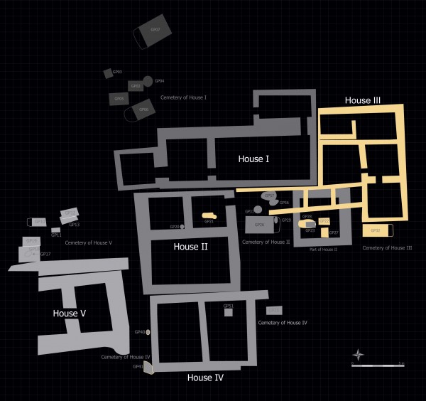
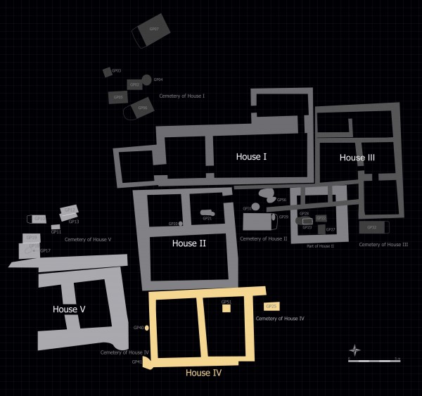
The sequence in which the houses were built can be partially reconstructed on the basis of their distribution and spatial relation. House III was the earliest among the houses of the area, having been erected probably at the turn of the MBA I period. The second in chronological order was House I, which had clearly been built against the already existing House III. It seems that House II was later than House I, but the remaining Houses IV and V, of which only the foundation levels have been preserved, could not be placed in the sequence.
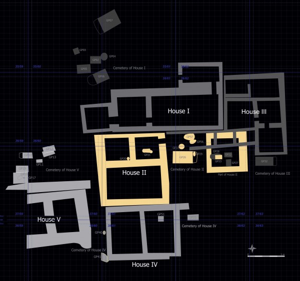
THE HOUSE PLAN
The original plan of Houses I, II and V seems to follow the same outline. The sides of the square structure did not exceed 10 meters in length. A large room occupied the southern half, while the northern one was divided into two (Houses II and V) or three (House I) compartments. The plan of House IV is difficult to reconstruct, but it may have been another house with three compartments in the northern part. This kind of house plan is not known in the Khabur Triangle area. Late Bronze Age houses in the Lower City area of Tell Bazi are the only analogy known to me (Otto 2006; 2014, Fig. 6).
Both House II and House I show clear signs of reconstructions and adaptations. In House II a large room was at a certain moment divided in two. The development of House I was much more complicated. It was extended towards the west by adding Room LP218 and, at a yet later stage, by adding another room, LP222. At some point, the northern part of the house was dismantled, and a smaller room was raised in its former north-eastern corner, with a doorway leading to a triangular courtyard covering the north-western part of the former house. In the latest phase, the house was probably divided into two units, with a division wall cutting across the main hall (LP243). The eastern unit, consisting of two rooms, used the former entrance. The western part of the house was served by a new doorway, which has not been identified during the excavations but was probably located in the northern wall of Room LP222. It is possible that the division of the house into separate entities coincided with the construction of two vaulted chamber graves (GP 06 and GP 07) to the north-west of the house.
CONSTRUCTION TECHNIQUE
Houses I, II, IV and V were constructed in a very similar manner. It seems that construction always started with the digging of foundation trenches, which in the case of House II were at least 1.6 m deep. They were filled with wet earth, probably the same which has been excavated when digging the trench, as suggested by the lack of 2nd-millennium pottery in pisé. After stabilizing the foundations, mudbrick superstructures were raised. Square bricks with side dimensions of 0.32 m and corresponding half-bricks were used for this purpose. They were bound with clay mortar; a kind of bond designated as ABC by Sauvage (1998, 62). Walls were usually 2-bricks-wide, resulting in a thickness of c. 0.7-0.65 m; only in the case of House I its southern wall was 2,5-brick-wide (thickness of c. 0.85 m). The walls were covered with clay plaster, as were the floors. There is no evidence of stairs. The low height of preservation of the extant walls suggests that there was no upper storey.
ACCOMPANYING STRUCTURES
It seems the houses were surrounded by open areas used for household and other activities. These areas usually featured many thin layers of tamped clay, reflecting changes in the level of usage. Only occasionally were installations discovered in these areas. This may result from the fact that the zone adjacent to the houses was used for digging graves. In fact, very few graves have been found under the floors of the houses (a typical type of burial for this period). The residents of the houses located on the eastern slope of Tell Arbid buried their dead in at least three small cemeteries located beside the houses, usually in areas related to the entrance to a particular house. This might be the reason for the lack of installations in the immediate vicinity of the houses.
It is plausible that the cemeteries were guarded by the residents of the houses. Episodes of looting, evidenced in graves GP006 and GP007 (and an unsuccessful attempt observed in the case of GP26), should be dated to a period when the houses in Sector P were already abandoned. However, it is impossible to say whether the robbers were people living in the houses of the MBA III period settlement (of which only some very scarce remains have been found during the excavations) or whether the looting took place later.
BIBLIOGRAPHY QUOTED
Otto, Adelheid
2006 Alltag und Gesellschaft zur Spätbronzezeit: Eine Fallstudie aus Tall Bazi (Syrien), [Subartu 19], Turnhout: Brepols.
2014 The Organisation of Residential Space in the Mitanni Kingdom as a Mirror of Different Models of Governance in: E. Cancik-Kirschbaum, N. Brisch, J. Eidem (eds.), Constituent, Confederate, and Conquered Space. The Emergence of Mittani State, Berlin: De Gruyter, 33-60.
Sauvage, Martin
1998 La brique et sa mis en œuvre en Mésopotamie. Des origines à l’époque achéménide. Paris: Éditions Recherche sur les Civilisations.